Jogorogo
| Jogorogo District | |
|---|---|
| district | |
 | |
| Coordinates: 7°31′17.9″S 111°15′07″E / 7.521639°S 111.25194°ECoordinates: 7°31′17.9″S 111°15′07″E / 7.521639°S 111.25194°E | |
| Country |
|
| Province | East Java |
| Elevation | 457 m (1,499 ft) |
| Time zone | GMT +7 |
Jogorogo is a district (kecamatan) in Ngawi Regency, East Java Province, Indonesia.
Geography
Jogorogo is part of Mount Lawu main system, which lies in northwest part of its slope.
Images gallery
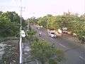 Jogorogo's Main Street
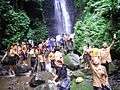 Students at Srambang Waterfall
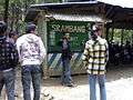 Srambang Waterfall Main Entrance
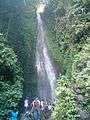 Srambang Waterfall
See also
References
This article is issued from Wikipedia - version of the 4/11/2016. The text is available under the Creative Commons Attribution/Share Alike but additional terms may apply for the media files.