Kéthely
| Kéthely | ||
|---|---|---|
| ||
 Kéthely Location of Kéthely | ||
| Coordinates: 46°38′46″N 17°23′38″E / 46.64605°N 17.39402°ECoordinates: 46°38′46″N 17°23′38″E / 46.64605°N 17.39402°E | ||
| Country |
| |
| County | Somogy | |
| Area | ||
| • Total | 49.06 km2 (18.94 sq mi) | |
| Population (2004) | ||
| • Total | 2,432 | |
| • Density | 49.57/km2 (128.4/sq mi) | |
| Time zone | CET (UTC+1) | |
| • Summer (DST) | CEST (UTC+2) | |
| Postal code | 8713 | |
| Area code(s) | 85 | |
Kéthely is a village in Somogy county, Hungary.
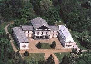
Aerialphotography: Kéthely, palace
External links
This article is issued from Wikipedia - version of the 2/6/2014. The text is available under the Creative Commons Attribution/Share Alike but additional terms may apply for the media files.