Kınık
| Kınık | |
|---|---|
| Town | |
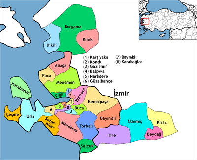 Location of Kınık within Turkey. | |
 Kınık Location of Kınık within Turkey. | |
| Coordinates: TR 39°05′38″N 27°22′36″E / 39.09389°N 27.37667°E | |
| Country |
|
| Region | Aegean |
| Province | İzmir |
| Area[1] | |
| • District | 446.33 km2 (172.33 sq mi) |
| Population (2012)[2] | |
| • Urban | 11,789 |
| • District | 27,950 |
| • District density | 63/km2 (160/sq mi) |
| Time zone | EET (UTC+2) |
| • Summer (DST) | EEST (UTC+3) |
| Postal code | 35990 |
Kınık is a district of İzmir Province of Turkey.
References
- ↑ "Area of regions (including lakes), km²". Regional Statistics Database. Turkish Statistical Institute. 2002. Retrieved 2013-03-05.
- ↑ "Population of province/district centers and towns/villages by districts - 2012". Address Based Population Registration System (ABPRS) Database. Turkish Statistical Institute. Retrieved 2013-02-27.
This article is issued from Wikipedia - version of the 2/11/2015. The text is available under the Creative Commons Attribution/Share Alike but additional terms may apply for the media files.