K-20 (Kansas highway)
| ||||
|---|---|---|---|---|
 | ||||
| Route information | ||||
| Maintained by KDOT | ||||
| Length: | 37.21 mi (59.88 km) | |||
| Major junctions | ||||
| West end: |
| |||
| East end: |
| |||
| Location | ||||
| Counties: | Brown, Doniphan | |||
| Highway system | ||||
| ||||

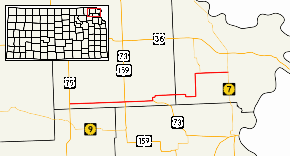
K-20 is a 37.21-mile-long (59.88 km) state highway in the northeastern part of the U.S. state of Kansas. It connects U.S. Route 75 in the Kickapoo Nation Indian Reservation with K-7 southwest of Troy.
Route description
K-20 begins at its western terminus at US-75 in southwest Brown County. It traverses the Kickapoo Nation Indian Reservation for 7 miles (11 km) until reaching Horton, where it begins a 5-mile-long (8.0 km) concurrency with U.S. Route 73 that ends at Everest. From there, K-20 continues east, as US-73 turns southeast, and passes by Purcell and intersects K-137 after crossing into Doniphan County. The route continues east for 5 miles (8.0 km) before turning north towards Denton. At Denton, the route turns east again and passes through Bendena, then terminates at K-7.[1]
Junction list
| County | Location | mi | km | Destinations | Notes |
|---|---|---|---|---|---|
| Brown | | 0.0 | 0.0 | Western terminus | |
| Horton | 10.9 | 17.5 | Western end of US-73 concurrency | ||
| Everest | 16.3 | 26.2 | Eastern end of US-73 concurrency | ||
| Doniphan | Purcell | 17.7 | 28.5 | ||
| | 27.2 | 43.8 | |||
| | 37.21 | 59.88 | Eastern terminus | ||
| 1.000 mi = 1.609 km; 1.000 km = 0.621 mi | |||||
See also
-
 Kansas portal
 -
 U.S. Roads portal
References
- ↑ Official Kansas Highway Map (PDF) (Map). Scale not given. Cartography by KSHC. Kansas State Highway Commission. 2016. § B10–C10. Retrieved March 12, 2015.