K-65 (Kansas highway)
| ||||
|---|---|---|---|---|
| Route information | ||||
| Maintained by KDOT | ||||
| Length: | 11.160 mi[1] (17.960 km) | |||
| Major junctions | ||||
| West end: |
| |||
| East end: |
| |||
| Location | ||||
| Counties: | Bourbon | |||
| Highway system | ||||
| ||||

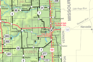
Map of Bourbon County (map legend)
K-65 is a state highway in Bourbon County in eastern Kansas. It is 11.160 miles (17.960 km) long. K-65 begins at K-3 in Franklin Township near the Allen County line, west of Xenia. K-65's western intersection is about seven miles (11 km) northeast of Bronson, and is just south of the Little Osage River.
K-65 heads east toward Mapleton, in Timber Hill Township, Bourbon County, and ends in Mapleton at K-31.
It is maintained by the Kansas Department of Transportation, and is a two-lane road its entire length.[2][3]
Junction list
The entire route is in Bourbon County.
| Location | mi[1] | km | Destinations | Notes | |
|---|---|---|---|---|---|
| | 0.000 | 0.000 | Western terminus | ||
| Mapleton | 11.160 | 17.960 | Eastern terminus | ||
| 1.000 mi = 1.609 km; 1.000 km = 0.621 mi | |||||
References
- 1 2 Kansas Department of Transportation (July 19, 2012). "2012 Condition Survey Report". Retrieved August 1, 2013.
- ↑ "Kansas Highways Routelog".
- ↑ "KDOT: Official Transportation Map".
External links
Municipalities and communities of Bourbon County, Kansas, United States | ||
|---|---|---|
| Cities | 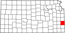 | |
| Unincorporated communities | ||
| Townships | ||
This article is issued from Wikipedia - version of the 3/11/2016. The text is available under the Creative Commons Attribution/Share Alike but additional terms may apply for the media files.