Kaliyakkavilai
| Kaliyakkavilai களியக்காவிளை | |
|---|---|
| city | |
| Nickname(s): Kunnamvilagam | |
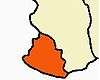
 Kaliyakkavilai Location in Tamil Nadu, India | |
| Coordinates: 8°19′22″N 77°09′14″E / 8.32278°N 77.15389°ECoordinates: 8°19′22″N 77°09′14″E / 8.32278°N 77.15389°E | |
| Country |
|
| State | Tamil Nadu |
| District | Kanniyakumari |
| Population (2001) | |
| • Total | 13,307 |
| Languages | |
| • Official | Tamil |
| Time zone | IST (UTC+5:30) |
| Vehicle registration | TN-75 |
Kaliyakkavilai is a panchayat town in Kanniyakumari district in the Indian state of Tamil Nadu, close to the Tamil Nadu-Kerala border. It lies on Coimbatore-Kochi-Trivandrum-Kanyakumari National highway 47.
Demographics
As of 2001 India census,[1] Kaliyakkavilai had a population of 13,307. Males constitute 49% of the population and females 51%. Kaliyakkavilai has an average literacy rate of 77%, higher than the national average of 59.5%: male literacy is 81%, and female literacy is 74%. In Kaliyakkavilai, 11% of the population is under 6 years of age.
References
- ↑ "Census of India 2001: Data from the 2001 Census, including cities, villages and towns (Provisional)". Census Commission of India. Archived from the original on 2004-06-16. Retrieved 2008-11-01.
This article is issued from Wikipedia - version of the 11/17/2016. The text is available under the Creative Commons Attribution/Share Alike but additional terms may apply for the media files.