Kalwang
| Kalwang | |
|---|---|
 Kalwang Location within Austria | |
| Coordinates: 47°24′36″N 14°45′00″E / 47.41000°N 14.75000°ECoordinates: 47°24′36″N 14°45′00″E / 47.41000°N 14.75000°E | |
| Country | Austria |
| State | Styria |
| District | Leoben |
| Government | |
| • Mayor | Mario Angerer (ÖVP) |
| Area | |
| • Total | 67.15 km2 (25.93 sq mi) |
| Elevation | 751 m (2,464 ft) |
| Population (1 January 2016)[1] | |
| • Total | 1,019 |
| • Density | 15/km2 (39/sq mi) |
| Time zone | CET (UTC+1) |
| • Summer (DST) | CEST (UTC+2) |
| Postal code | 8775 |
| Area code | 03846 |
| Vehicle registration | LN |
| Website | www.kalwang.at |
Kalwang is a municipality in the district of Leoben in the Austrian state of Styria.
Neighboring municipalities
| Radmer | Eisenerz | ||
| Wald am Schoberpaß | |
Trofaiach | |
| |||
| | |||
| Mautern in Steiermark |

References
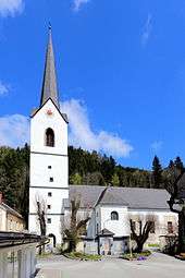
Parish church St. Oswald
This article is issued from Wikipedia - version of the 10/14/2016. The text is available under the Creative Commons Attribution/Share Alike but additional terms may apply for the media files.