Killarney, West Virginia
| Killarney, West Virginia | |
|---|---|
| Unincorporated community | |
|
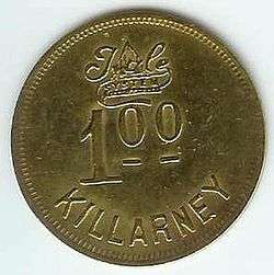
coal scrip from Killarney, West Virginia | |
 Killarney, West Virginia  Killarney, West Virginia | |
| Coordinates: 37°37′41″N 81°16′37″W / 37.62806°N 81.27694°WCoordinates: 37°37′41″N 81°16′37″W / 37.62806°N 81.27694°W | |
| Country | United States |
| State | West Virginia |
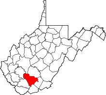
| County | Raleigh |
| Elevation | 1,693 ft (516 m) |
| Time zone | Eastern (EST) (UTC-5) |
| • Summer (DST) | EDT (UTC-4) |
| Area code(s) | 304 & 681 |
| GNIS feature ID | 1541192[1] |
Killarney was an unincorporated community in Raleigh County, West Virginia, United States. Killarney is 5.5 miles (8.9 km) south-southwest of Sophia.
References
- ↑ "US Board on Geographic Names". United States Geological Survey. 2007-10-25. Retrieved 2008-01-31.
This article is issued from Wikipedia - version of the 7/28/2016. The text is available under the Creative Commons Attribution/Share Alike but additional terms may apply for the media files.