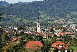
Kirchdorf an der Krems
| Kirchdorf an der Krems | ||
|---|---|---|
 | ||
| ||
 Kirchdorf an der Krems Location within Austria | ||
| Coordinates: 47°54′24″N 14°0′0″E / 47.90667°N 14.00000°ECoordinates: 47°54′24″N 14°0′0″E / 47.90667°N 14.00000°E | ||
| Country | Austria | |
| State | Upper Austria | |
| District | Kirchdorf an der Krems | |
| Government | ||
| • Mayor | Wolfgang Veitz (SPÖ) | |
| Area | ||
| • Total | 2.8 km2 (1.1 sq mi) | |
| Elevation | 450 m (1,480 ft) | |
| Population (14 June 2016)[1] | ||
| • Total | 4,323 | |
| • Density | 1,500/km2 (4,000/sq mi) | |
| Time zone | CET (UTC+1) | |
| • Summer (DST) | CEST (UTC+2) | |
| Postal code | 4560 | |
| Area code | 07582 | |
| Vehicle registration | KI | |
| Website | www.kirchdorf.at | |

Kirchdorf an der Krems is a town in the Austrian state of Upper Austria on the river Krems, in the district of Kirchdorf an der Krems. Apparently settled by the year 903,
Population
| Historical population | ||
|---|---|---|
| Year | Pop. | ±% |
| 1869 | 1,534 | — |
| 1880 | 1,522 | −0.8% |
| 1890 | 1,613 | +6.0% |
| 1900 | 1,602 | −0.7% |
| 1910 | 1,769 | +10.4% |
| 1923 | 1,738 | −1.8% |
| 1934 | 1,707 | −1.8% |
| 1939 | 1,862 | +9.1% |
| 1951 | 2,632 | +41.4% |
| 1961 | 2,964 | +12.6% |
| 1971 | 3,512 | +18.5% |
| 1981 | 3,702 | +5.4% |
| 1991 | 3,738 | +1.0% |
| 2001 | 4,099 | +9.7% |
| 2011 | 4,048 | −1.2% |
Personalities
References
| Wikimedia Commons has media related to Kirchdorf an der Krems. |
This article is issued from Wikipedia - version of the 3/17/2016. The text is available under the Creative Commons Attribution/Share Alike but additional terms may apply for the media files.