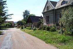
Klabava
| Klabava | |||
|---|---|---|---|
| Municipality | |||
 | |||
| |||
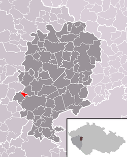 Location in Rokycany District | |||
 Klabava Location in the Czech Republic | |||
| Coordinates: 49°45′28″N 13°32′14″E / 49.75778°N 13.53722°ECoordinates: 49°45′28″N 13°32′14″E / 49.75778°N 13.53722°E | |||
| Country |
| ||
| Region | Plzeň | ||
| District | Rokycany | ||
| Area | |||
| • Total | 1.54 km2 (0.59 sq mi) | ||
| Elevation | 379 m (1,243 ft) | ||
| Population (2015-01-01) | |||
| • Total | 461 | ||
| • Density | 300/km2 (780/sq mi) | ||
| Postal code | 338 41 | ||
| Website | http://www.klabava.eu | ||

Klabava is a village and municipality (obec) in Rokycany District in the Plzeň Region of the Czech Republic.
The municipality covers an area of 1.54 square kilometres (0.59 sq mi), and has a population of 419 (as at 28 August 2006).
Klabava lies approximately 4 kilometres (2 mi) west of Rokycany, 12 km (7 mi) east of Plzeň, and 74 km (46 mi) south-west of Prague.
References
This article is issued from Wikipedia - version of the 11/26/2016. The text is available under the Creative Commons Attribution/Share Alike but additional terms may apply for the media files.