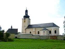
Koclířov
| Koclířov | |||
|---|---|---|---|
| Municipality | |||
 | |||
| |||
 Koclířov | |||
| Coordinates: 49°46′0″N 16°32′28″E / 49.76667°N 16.54111°ECoordinates: 49°46′0″N 16°32′28″E / 49.76667°N 16.54111°E | |||
| Country |
| ||
| Region | Pardubice | ||
| District | Svitavy | ||
| Area | |||
| • Total | 17.3 km2 (6.7 sq mi) | ||
| Elevation | 502 m (1,647 ft) | ||
| Population (1.1.2014) | |||
| • Total | 693 | ||
| • Density | 40/km2 (100/sq mi) | ||
| Postal code | 569 11 | ||
| Website | http://www.svitavskoweb.cz/place.asp?place=8 | ||

Koclířov is a village and municipality (obec) in Svitavy District in the Pardubice Region of the Czech Republic.
The municipality covers an area of 17.3 square kilometres (6.7 sq mi), and has a population of 700 (as at 2 July 2007).
Koclířov lies approximately 6 kilometres (4 mi) east of Svitavy, 63 km (39 mi) south-east of Pardubice, and 157 km (98 mi) east of Prague.
References
| Wikimedia Commons has media related to Koclířov. |
This article is issued from Wikipedia - version of the 4/7/2016. The text is available under the Creative Commons Attribution/Share Alike but additional terms may apply for the media files.