Kothakota
| Kothakota కొత్తకోట | |
|---|---|
|
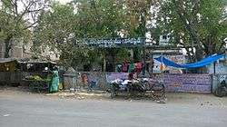
Panchayat Office(old police station), Kothakota | |
 Kothakota  Kothakota Location in Telangana, India | |
| Coordinates: 16°22′00″N 77°58′00″E / 16.3667°N 77.9667°ECoordinates: 16°22′00″N 77°58′00″E / 16.3667°N 77.9667°E | |
| Country |
|
| State | Telangana |
| District | Wanaparthy |
| Elevation | 401 m (1,316 ft) |
| Telugu, ududhu | |
| • Official | Telugu |
| Time zone | IST (UTC+5:30) |
| PIN | 509381 |
| Vehicle registration | TS06 |
| Nearest city | Wanaparthy |
| Lok Sabha constituency | Mahabubnagar |
| Vidhan Sabha constituency | Devarakadra |
| Climate | hot (Köppen) |
| Website |
telangana |
Kothakota is a town and mandal in Wanaparthy district, Telangana. It has an MRO office, Govt. junior college.
Geography
Kothakota is located at 16°22′00″N 77°58′00″E / 16.3667°N 77.9667°E.[1] It has an average elevation of 401 metres (1318 ft).
References
- ↑ "Maps, Weather, and Airports for Kothakota, India". Fallingrain.com. Retrieved 2016-12-01.
This article is issued from Wikipedia - version of the 12/1/2016. The text is available under the Creative Commons Attribution/Share Alike but additional terms may apply for the media files.