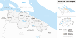
Kreuzlingen District
| Kreuzlingen District Bezirk Kreuzlingen | |
|---|---|
| District | |
 | |
| Country |
|
| Canton |
|
| Capital | Kreuzlingen |
| Area | |
| • Total | 129.0 km2 (49.8 sq mi) |
| Population (2015) | |
| • Total | 46,591 |
| • Density | 360/km2 (940/sq mi) |
| Time zone | CET (UTC+1) |
| • Summer (DST) | CEST (UTC+2) |
| Municipalities | 14 |
Kreuzlingen District is one of the five districts of the canton of Thurgau in Switzerland. It has a population of 46,591 (as of 31 December 2015).[1] Its capital is the city of Kreuzlingen.
The district contains the following municipalities:
| Coat of arms | Municipality | Population (31 December 2015)[2] |
Area km²[3] |
|---|---|---|---|
| | Altnau | 2,149 | 6.7 |
| | Bottighofen | 2,171 | 2.4 |
| | Ermatingen | 3,202 | 10.4 |
| | Gottlieben | 325 | 0.4 |
| | Güttingen | 1,574 | 9.5 |
| | Kemmental | 2,393 | 28.4 |
| | Kreuzlingen | 21,542 | 11.5 |
| | Langrickenbach | 1,276 | 10.9 |
| | Lengwil | 1,659 | 8.9 |
| | Münsterlingen | 3,199 | 5.4 |
| | Raperswilen | 395 | 7.7 |
| | Salenstein | 1,282 | 6.6 |
| | Tägerwilen | 4,388 | 11.6 |
| | Wäldi | 1,036 | 12.3 |
| Total (14) | 46,591 | 129.0 |
References
- ↑ Swiss Federal Statistical Office - STAT-TAB, online database – Ständige und nichtständige Wohnbevölkerung nach institutionellen Gliederungen, Geburtsort und Staatsangehörigkeit (German) accessed 30 August 2016
- ↑ Swiss Federal Statistical Office - STAT-TAB, online database – Ständige und nichtständige Wohnbevölkerung nach institutionellen Gliederungen, Geburtsort und Staatsangehörigkeit (German) accessed 30 August 2016
- ↑ Swiss Federal Statistical Office-Land Use Statistics 2009 data (German) accessed 25 March 2010
Coordinates: 47°38′N 9°10′E / 47.633°N 9.167°E
This article is issued from Wikipedia - version of the 8/25/2014. The text is available under the Creative Commons Attribution/Share Alike but additional terms may apply for the media files.