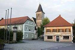
Kronstorf
| Kronstorf | ||
|---|---|---|
 | ||
| ||
 Kronstorf Location within Austria | ||
| Coordinates: 48°8′34″N 14°28′0″E / 48.14278°N 14.46667°ECoordinates: 48°8′34″N 14°28′0″E / 48.14278°N 14.46667°E | ||
| Country | Austria | |
| State | Upper Austria | |
| District | Linz-Land | |
| Government | ||
| • Mayor | Christian Kolarik (ÖVP) | |
| Area | ||
| • Total | 21 km2 (8 sq mi) | |
| Elevation | 277 m (909 ft) | |
| Population (14 June 2016)[1] | ||
| • Total | 3,228 | |
| • Density | 150/km2 (400/sq mi) | |
| Time zone | CET (UTC+1) | |
| • Summer (DST) | CEST (UTC+2) | |
| Postal code | 4484 | |
| Area code | 07225 | |
| Vehicle registration | LL | |
| Website | www.kronstorf.at | |
Kronstorf is a municipality in the district Linz-Land in the Austrian state of Upper Austria.
Population
| Historical population | ||
|---|---|---|
| Year | Pop. | ±% |
| 1869 | 1,073 | — |
| 1880 | 1,183 | +10.3% |
| 1890 | 1,174 | −0.8% |
| 1900 | 1,246 | +6.1% |
| 1910 | 1,236 | −0.8% |
| 1923 | 1,200 | −2.9% |
| 1934 | 1,162 | −3.2% |
| 1939 | 1,179 | +1.5% |
| 1951 | 1,619 | +37.3% |
| 1961 | 1,872 | +15.6% |
| 1971 | 2,209 | +18.0% |
| 1981 | 2,278 | +3.1% |
| 1991 | 2,418 | +6.1% |
| 2001 | 3,002 | +24.2% |
| 2011 | 3,140 | +4.6% |
References
| Wikimedia Commons has media related to Kronstorf. |
This article is issued from Wikipedia - version of the 11/4/2016. The text is available under the Creative Commons Attribution/Share Alike but additional terms may apply for the media files.