Kyongsong Chuul Airport
| Kyongsong Chuul Airport | |||||||||||
|---|---|---|---|---|---|---|---|---|---|---|---|
 | |||||||||||
| IATA: N/A – ICAO: N/A – FAA LID: N/A | |||||||||||
| Summary | |||||||||||
| Airport type | Military | ||||||||||
| Serves | Kyongsong, North Korea | ||||||||||
| Elevation AMSL | 3 ft / 1 m | ||||||||||
| Coordinates | 41°33′37.60″N 129°37′50.10″E / 41.5604444°N 129.6305833°E | ||||||||||
| Runways | |||||||||||
| |||||||||||
| Kyongsong Chuul Airport | |
| Chosŏn'gŭl | 경성주을비행장 |
|---|---|
| Hancha | 鏡城朱乙飛行場 |
| Revised Romanization | Gyeongseong Jueul bihaengjang |
| McCune–Reischauer | Kyŏngsŏng Chuŭl pihaengjang |
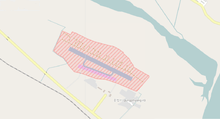
Kyongsong Chuul Airport is an airport in Kyongsong-gun, Hamgyong-bukto, North Korea.
Facilities
The airfield has a single asphalt runway 13/31 measuring 3500 x 200 feet (1067 x 61 m).[1][2]
It is sited on the east coast of North Korea, a few miles north of the Orang Airport and south of the city of Chongjin.
References
- ↑ Landings database page "Landings.Com", accessed 12 Aug 2010,
- ↑ GlobalSecurity.org "Air Bases - Kyongsong-Chuul", accessed 12 Aug 2010,
This article is issued from Wikipedia - version of the 6/13/2015. The text is available under the Creative Commons Attribution/Share Alike but additional terms may apply for the media files.