La Carrillo
| La Carrillo | |
|---|---|
| Corregimiento | |
 La Carrillo | |
| Coordinates: 7°58′00″N 80°53′00″W / 7.96667°N 80.88333°WCoordinates: 7°58′00″N 80°53′00″W / 7.96667°N 80.88333°W | |
| Country |
|
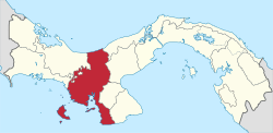
| Province | Veraguas |
| District | Atalaya |
| Established | July 29, 1998[1] |
| Area[1] | |
| • Land | 39.3 km2 (15.2 sq mi) |
| Population (2010)[1] | |
| • Total | 630 |
| • Density | 16/km2 (40/sq mi) |
| Population density calculated based on land area. | |
| Time zone | EST (UTC−5) |
La Carrillo is a corregimiento in Atalaya District, Veraguas Province, Panama with a population of 630 as of 2010.[1] It was created by Law 58 of July 29, 1998, owing to the Declaration of Unconstitutionality of Law 1 of 1982. [1] Its population as of 2000 was 750.[1]
References
- 1 2 3 4 5 6 "Cuadro 11 (Superficie, población y densidad de población en la República...)" [Table 11 (Area, population, and population density in the Republic...)] (.xls). In "Resultados Finales Básicos" [Basic Final Results] (in Spanish). National Institute of Statistics and Census of Panama. Retrieved May 26, 2015.
This article is issued from Wikipedia - version of the 10/8/2015. The text is available under the Creative Commons Attribution/Share Alike but additional terms may apply for the media files.