Labeaume
| Labeaume | ||
|---|---|---|
|
A general view of Labeaume | ||
| ||
 Labeaume | ||
|
Location within Auvergne-Rhône-Alpes region  Labeaume | ||
| Coordinates: 44°27′00″N 4°18′26″E / 44.45°N 4.3072°ECoordinates: 44°27′00″N 4°18′26″E / 44.45°N 4.3072°E | ||
| Country | France | |
| Region | Auvergne-Rhône-Alpes | |
| Department | Ardèche | |
| Arrondissement | Largentière | |
| Canton | Joyeuse | |
| Government | ||
| • Mayor (2008–2014) | Gérard Marron | |
| Area1 | 17.76 km2 (6.86 sq mi) | |
| Population (2008)2 | 572 | |
| • Density | 32/km2 (83/sq mi) | |
| Time zone | CET (UTC+1) | |
| • Summer (DST) | CEST (UTC+2) | |
| INSEE/Postal code | 07115 / 07120 | |
| Elevation |
99–265 m (325–869 ft) (avg. 140 m or 460 ft) | |
|
1 French Land Register data, which excludes lakes, ponds, glaciers > 1 km² (0.386 sq mi or 247 acres) and river estuaries. 2 Population without double counting: residents of multiple communes (e.g., students and military personnel) only counted once. | ||
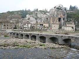

Labeaume is a commune in the Ardèche department in southern France.
A little different in nature from the other 'villages of character', Labeaume is situated around an open square with a church and has a handful of old streets to explore as expected, with ancient houses lining narrow alleys.[1]
Population
| Historical population | ||
|---|---|---|
| Year | Pop. | ±% |
| 1962 | 341 | — |
| 1968 | 346 | +1.5% |
| 1975 | 357 | +3.2% |
| 1982 | 405 | +13.4% |
| 1990 | 455 | +12.3% |
| 1999 | 493 | +8.4% |
| 2008 | 572 | +16.0% |
See also
References
| Wikimedia Commons has media related to Labeaume. |
This article is issued from Wikipedia - version of the 3/15/2016. The text is available under the Creative Commons Attribution/Share Alike but additional terms may apply for the media files.