Lake Itkul
| Itkul | |
|---|---|
 lake Itkul | |
| Coordinates | 56°05′N 60°18′E / 56.09°N 60.3°E |
| Primary inflows | Dolgaya, Shardatma, Zyuzelka, Karabayka, Kamenuchka |
| Primary outflows | Istok |
| Catchment area | 154 km2 (0 sq mi) |
| Basin countries | Russia |
| Max. length | 7 km (4.3 mi) |
| Max. width | 5 km (3.1 mi) |
| Surface area | 30 km2 (12 sq mi) |
| Average depth | 7.8 m (26 ft) |
| Max. depth | 16.6 m (54 ft) |
| Water volume | 0.0234 km3 (0 cu mi) |
| Surface elevation | 273 m (896 ft) |
| Frozen | November–May |
| Islands | 1 |
| Settlements | Verkhny Ufaley |
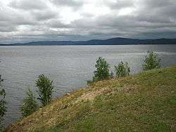
Itkul is a lake situated in the north of the Chelyabinsk oblast, 20 kilometers from the town of Verkhny Ufaley. Lake Itkul was declared a natural monument.
The lake is surrounded by low Ural mountains, the highest of them being Karabayka (544 m) on the south-western shore of Lake Itkul. Here in Lake Itkul small river flows Karabayka.
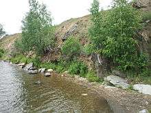
Lakeside Itkul
This article is issued from Wikipedia - version of the 5/13/2015. The text is available under the Creative Commons Attribution/Share Alike but additional terms may apply for the media files.