Lansingerland
| Lansingerland | |||
|---|---|---|---|
| Municipality | |||
|
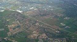
Aerial view of Berkel en Rodenrijs | |||
| |||
.svg.png) Location in South Holland | |||
| Coordinates: 51°59′N 4°30′E / 51.983°N 4.500°ECoordinates: 51°59′N 4°30′E / 51.983°N 4.500°E | |||
| Country | Netherlands | ||
| Province | South Holland | ||
| Established | 1 January 2007[1] | ||
| Government[2] | |||
| • Body | Municipal council | ||
| • Mayor | Pieter van de Stadt | ||
| Area[3] | |||
| • Total | 56.37 km2 (21.76 sq mi) | ||
| • Land | 54.28 km2 (20.96 sq mi) | ||
| • Water | 2.09 km2 (0.81 sq mi) | ||
| Elevation[4] | −5 m (−16 ft) | ||
| Population (May 2014)[5] | |||
| • Total | 57,545 | ||
| • Density | 1,060/km2 (2,700/sq mi) | ||
| Time zone | CET (UTC+1) | ||
| • Summer (DST) | CEST (UTC+2) | ||
| Postcode | 2650–2665 | ||
| Area code | 010 | ||
| Website |
www | ||

Lansingerland is the name for the new municipality in the western Netherlands, in the province of South Holland. It was formed on 1 January 2007, by the merger of the municipalities of Berkel en Rodenrijs, Bleiswijk and Bergschenhoek, collectively known as the "B-Triangle". The former municipality of Tempel, abolished in 1855, is also part of Lansingerland.
The name was chosen from a competition and derived from the name Lansingh, the height-of-land between the Delfland and Schieland Water Boards, which runs between the "B-Triangle" villages. The choice of name is symbolic: the name of the border that formerly divided the area, now unites it. The "h" in Lansingh was dropped to ease spelling.
Lansingerland consists of the following communities:
- Bergschenhoek
- Berkel en Rodenrijs
- Bleiswijk
- Tempel (deserted)
- De Rotte
- Kruisweg
Topography
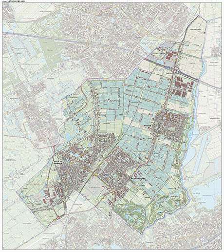
Dutch Topographic map of the municipality of Lansingerland, June 2015
Politics
On 18 September 2007 Ewald van Vliet was installed as the first mayor of Lansingerland.
| Mayors | |||||||||||||||
|---|---|---|---|---|---|---|---|---|---|---|---|---|---|---|---|
| Year | Mayor | ||||||||||||||
| 2015 | Pieter van de Stadt | ||||||||||||||
| 2014 | Coos Rijsdijk | ||||||||||||||
| 2007 | Ewald van Vliet | ||||||||||||||
The municipal council of Lansingerland consists of 31 seats. They were last contested in March 2014 and the results were as follows:
| Council seats | |||||||||||||||
|---|---|---|---|---|---|---|---|---|---|---|---|---|---|---|---|
| Party | 2010 | 2014 | |||||||||||||
| Partij van de Arbeid (Nederland) - PvdA | 3 | 2 | |||||||||||||
| Christen Democratisch Appèl - CDA | 6 | 6 | |||||||||||||
| Volkspartij voor Vrijheid en Democratie - VVD | 6 | 5 | |||||||||||||
| GroenLinks | 1 | 1 | |||||||||||||
| Leefbaar 3B | 9 | 7 | |||||||||||||
| Partij tot Behoud Huis de Haas | 1 | - | |||||||||||||
| Nieuw Rechts | 0 | 0 | |||||||||||||
| D66 | 2 | 4 | |||||||||||||
| ChristenUnie | 3 | 3 | |||||||||||||
| WIJ Lansingerland | - | 2 | |||||||||||||
| Partij Neeleman | - | 1 | |||||||||||||
| Total | 31 | 31 | |||||||||||||
References
- ↑ "Gemeentelijke indeling op 1 januari 2007" [Municipal divisions on 1 January 2007]. cbs.nl (in Dutch). CBS. Retrieved 6 August 2013.
- ↑ "Samenstelling B&W" [Mayor and aldermen] (in Dutch). Gemeente Lansingerland. Retrieved 6 August 2014.
- ↑ "Kerncijfers wijken en buurten" [Key figures for neighbourhoods]. CBS Statline (in Dutch). CBS. 2 July 2013. Retrieved 12 March 2014.
- ↑ "Postcodetool for 2662SB". Actueel Hoogtebestand Nederland (in Dutch). Het Waterschapshuis. Retrieved 7 August 2013.
- ↑ "Bevolkingsontwikkeling; regio per maand" [Population growth; regions per month]. CBS Statline (in Dutch). CBS. 26 June 2014. Retrieved 24 July 2014.
External links
 |
Zoetermeer | Alphen aan den Rijn | | |
| Pijnacker-Nootdorp | |
Rotte / Zuidplas | ||
| ||||
| | ||||
| Rotterdam |
