Le Pas
This article is about the commune in France. For the town in Canada, see The Pas. For other uses, see PAS.
| Le Pas | |
|---|---|
|
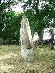
The Menhir of Saint Civière, in Le Pas | |
 Le Pas | |
|
Location within Pays de la Loire region  Le Pas | |
| Coordinates: 48°25′51″N 0°41′55″W / 48.4308°N 0.6986°WCoordinates: 48°25′51″N 0°41′55″W / 48.4308°N 0.6986°W | |
| Country | France |
| Region | Pays de la Loire |
| Department | Mayenne |
| Arrondissement | Mayenne |
| Canton | Ambrières-les-Vallées |
| Government | |
| • Mayor (2008–2014) | Roland Havard |
| Area1 | 21.90 km2 (8.46 sq mi) |
| Population (2006)2 | 523 |
| • Density | 24/km2 (62/sq mi) |
| Time zone | CET (UTC+1) |
| • Summer (DST) | CEST (UTC+2) |
| INSEE/Postal code | 53176 / 53300 |
| Elevation |
98–190 m (322–623 ft) (avg. 95 m or 312 ft) |
|
1 French Land Register data, which excludes lakes, ponds, glaciers > 1 km² (0.386 sq mi or 247 acres) and river estuaries. 2 Population without double counting: residents of multiple communes (e.g., students and military personnel) only counted once. | |
Le Pas is a commune in the Mayenne department in north-western France.
See also
| Wikimedia Commons has media related to Le Pas (Mayenne). |
This article is issued from Wikipedia - version of the 2/14/2015. The text is available under the Creative Commons Attribution/Share Alike but additional terms may apply for the media files.