Le Rocher-Percé Regional County Municipality
| Le Rocher-Percé | |
|---|---|
| Regional county municipality | |
 | |
| Coordinates: 48°22′N 64°37′W / 48.367°N 64.617°WCoordinates: 48°22′N 64°37′W / 48.367°N 64.617°W[1] | |
| Country |
|
| Province |
|
| Region | Gaspésie–Îles-de-la-Madeleine |
| Effective | April 1, 1981 |
| County seat | Chandler |
| Government[2] | |
| • Type | Prefecture |
| • Prefect | Nadia Minassian |
| Area[2][3] | |
| • Total | 3,249.20 km2 (1,254.52 sq mi) |
| • Land | 3,077.81 km2 (1,188.35 sq mi) |
| Population (2011)[3] | |
| • Total | 17,979 |
| • Density | 5.8/km2 (15/sq mi) |
| • Pop 2006-2011 |
|
| • Dwellings | 8,622 |
| Time zone | EST (UTC−5) |
| • Summer (DST) | EDT (UTC−4) |
| Area code(s) | 418 and 581 |
| Website |
www |
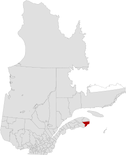
Rocher-Percé is a regional county municipality in the Gaspésie–Îles-de-la-Madeleine region of Quebec, Canada. Its seat is Chandler.
Prior to July 17, 1999 it was known as Pabok Regional County Municipality.[4]
It is named after Percé Rock (the pierced rock), a massive arched sandstone rock rising from the Atlantic just off the tip of the Gaspé peninsula. The region includes the towns of Percé, Grande-Rivière, Port-Daniel–Gascons and Chandler. Major tourist attractions include the Percé Rock and Bonaventure Island.
Subdivisions
There are 6 subdivisions within the RCM:[2]
|
|
|
Demographics
Population
| Canada census – Le Rocher-Percé Regional County Municipality, Quebec community profile | |||
|---|---|---|---|
| 2011 | 2006 | 2001 | |
| Population: | 17,979 (-2.5% from 2006) | 18,437 (-4.5% from 2001) | 19,298 (-9.6% from 1996) |
| Land area: | 3,077.81 km2 (1,188.35 sq mi) | 3,077.78 km2 (1,188.34 sq mi) | 3,077.82 km2 (1,188.35 sq mi) |
| Population density: | 5.8/km2 (15/sq mi) | 6.0/km2 (16/sq mi) | 6.3/km2 (16/sq mi) |
| Median age: | 50.6 (M: 50.0, F: 51.3) | 47.1 (M: 46.4, F: 47.8) | 43.2 (M: 42.9, F: 43.6) |
| Total private dwellings: | 8,622 | 8,669 | 8,630 |
| Median household income: | $38,549 | $36,080 | $29,680 |
| References: 2011[3] 2006[5] 2001[6] | |||
| Historical Census Data - Le Rocher-Percé Regional County Municipality, Quebec[7] | ||||||||||||||||||||||||||
|---|---|---|---|---|---|---|---|---|---|---|---|---|---|---|---|---|---|---|---|---|---|---|---|---|---|---|
|
|
| ||||||||||||||||||||||||
Language
| Canada Census Mother Tongue - Le Rocher-Percé Regional County Municipality, Quebec[7] | ||||||||||||||||||
|---|---|---|---|---|---|---|---|---|---|---|---|---|---|---|---|---|---|---|
| Census | Total | French |
English |
French & English |
Other | |||||||||||||
| Year | Responses | Count | Trend | Pop % | Count | Trend | Pop % | Count | Trend | Pop % | Count | Trend | Pop % | |||||
| 2011 |
17,870 |
16,325 | |
91.35% | 1,385 | |
7.75% | 115 | |
0.64% | 45 | |
0.25% | |||||
| 2006 |
18,265 |
16,675 | |
91.29% | 1,315 | |
7.20% | 30 | |
0.16% | 245 | |
1.34% | |||||
| 2001 |
19,170 |
17,620 | |
91.91% | 1,430 | |
7.46% | 90 | |
0.47% | 30 | |
0.16% | |||||
| 1996 |
21,230 |
19,315 | n/a | 90.98% | 1,655 | n/a | 7.80% | 225 | n/a | 1.06% | 35 | n/a | 0.16% | |||||
Transportation
Access Routes
Highways and numbered routes that run through the municipality, including external routes that start or finish at the county border:[8]
|
|
|
|
See also
References
- ↑ Reference number 351206 of the Commission de toponymie du Québec (French)
- 1 2 3 Geographic code 020 in the official Répertoire des municipalités (French)
- 1 2 3 "2011 Community Profiles". Canada 2011 Census. Statistics Canada. July 5, 2013. Retrieved 2014-04-20.
- ↑ http://www.stat.gouv.qc.ca/publications/referenc/pdf/mod0799.pdf
- ↑ "2006 Community Profiles". Canada 2006 Census. Statistics Canada. March 30, 2011. Retrieved 2014-04-20.
- ↑ "2001 Community Profiles". Canada 2001 Census. Statistics Canada. February 17, 2012. Retrieved 2014-04-20.
- 1 2 Statistics Canada: 1996, 2001, 2006, 2011 census
- ↑ Official Transport Quebec Road Map
 |
La Côte-de-Gaspé RCM | | ||
| Bonaventure RCM | |
Gulf of Saint Lawrence Les Îles-de-la-Madeleine TE | ||
| ||||
| | ||||
| Chaleur Bay |
| Regional county municipalities and equivalent territories | |
|---|---|
| Municipalities | |
This article is issued from Wikipedia - version of the 3/10/2016. The text is available under the Creative Commons Attribution/Share Alike but additional terms may apply for the media files.