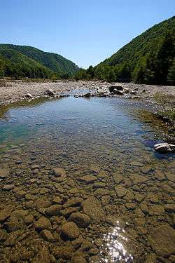
Lepșa River
Not to be confused with Lepsy River.
| Lepșa River | |
| River | |
 Lepșa River | |
| Countries | Romania |
|---|---|
| Counties | Vrancea County |
| Tributaries | |
| - left | Sagău, Lepuș |
| - right | Corimbat, Strâmba |
| Source | Mount Tâmla |
| - location | Vrancea Mountains |
| - elevation | 1,217 m (3,993 ft) |
| - coordinates | 46°02′11″N 26°26′32″E / 46.03639°N 26.44222°E |
| Mouth | Putna |
| - location | Lepșa |
| - elevation | 576 m (1,890 ft) |
| - coordinates | 45°56′54″N 26°34′24″E / 45.94833°N 26.57333°ECoordinates: 45°56′54″N 26°34′24″E / 45.94833°N 26.57333°E |
| Progression | Putna→ Siret→ Danube→ Black Sea |
The Lepșa River is a left tributary of the river Putna in Romania.[1] It discharges into the Putna in Lepșa.
References
- ↑ Ovidiu Gabor - Economic Mechanism in Water Management at the Wayback Machine (archived 5 March 2009), map page 10
- Administrația Națională Apelor Române - Cadastrul Apelor - București
- Institutul de Meteorologie și Hidrologie - Rîurile României - București 1971
- Trasee turistice - Vrancea
This article is issued from Wikipedia - version of the 11/15/2016. The text is available under the Creative Commons Attribution/Share Alike but additional terms may apply for the media files.