Little Ring Mountain
| Little Ring Mountain | |
|---|---|
 | |
| Highest point | |
| Elevation | 2,165 m (7,103 ft) |
| Prominence | 450 m (1,480 ft) |
| Listing | |
| Coordinates | 50°16′45.0″N 123°18′56.0″W / 50.279167°N 123.315556°W |
| Geography | |
| Location | British Columbia, Canada |
| Parent range | Pacific Ranges |
| Topo map | NTS 92J/06 |
| Geology | |
| Mountain type | Tuya |
| Volcanic arc/belt |
Canadian Cascade Arc Garibaldi Volcanic Belt |
| Climbing | |
| First ascent | 1969 John Clarke |
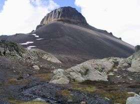
Little Ring Mountain, also called Little Ring Peak, is a tuya in the Pacific Ranges of the Coast Mountains in southwestern British Columbia, Canada. It lies at the head of the Squamish and Soo Rivers.[1] Part of the Mount Cayley volcanic field, its most recent eruption most likely occurred during the Fraser Glaciation.[2]
This peak is so-called because it is similar to the larger and officially named Ring Mountain just to the south.
See also
References
- ↑ Little Ring Peak in the Canadian Mountain Encyclopedia
- ↑ Catalogue of Canadian volcanoes: Little Ring Mountain
External links
This article is issued from Wikipedia - version of the 6/21/2013. The text is available under the Creative Commons Attribution/Share Alike but additional terms may apply for the media files.