Lonimavla Dam
| Lonimavla Dam | |
|---|---|
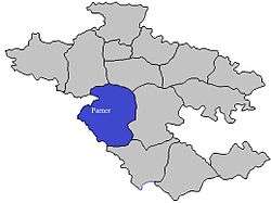
 Location of Lonimavla Dam in India Maharashtra | |
| Official name | Lonimavla Dam |
| Location |
Lonimawala, Parner India |
| Coordinates | 19°0′40″N 74°19′24″E / 19.01111°N 74.32333°ECoordinates: 19°0′40″N 74°19′24″E / 19.01111°N 74.32333°E |
| Opening date | 1981 |
| Owner(s) | Government of Maharashtra, India |
| Dam and spillways | |
| Type of dam | Earth-fill (Earthen) |
| Impounds | Local Nallah River |
| Height | 10 m (33 ft) |
| Length | 958 m (3,143 ft) |
| Reservoir | |
| Creates | Lonimavla lake |
| Total capacity | 880 km3 (210 cu mi) |
| Surface area | 46 km2 (18 sq mi) |
Lonimavla Dam (Marathi: लोणीमावळा धरण), is an earth-fill dam in Lonimawala village in Parner taluka of Ahmednagar district of state of Maharashtra in India.
Specifications
The height of the dam above lowest foundation is 10 m (33 ft) while the length is 958 m (3,143 ft). The gross storage capacity is 1,080 km3 (260 cu mi).[1]
Purpose
- Irrigation
- Drinking water for neatest villages
See also
References
Ahmednagar district topics | ||
|---|---|---|
| History | 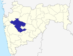 | |
| Geography | ||
| Talukas | ||
| Cities and towns | ||
| Monuments | ||
| Education | ||
| Lok Sabha constituencies | ||
| Vidhan Sabha constituencies | ||
| Dams in District | ||
This article is issued from Wikipedia - version of the 9/18/2015. The text is available under the Creative Commons Attribution/Share Alike but additional terms may apply for the media files.