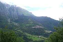
Lozio
| Lozio Lóh | |
|---|---|
| Comune | |
| Comune di Lozio | |
|
Lozio | |
 Lozio Location of Lozio in Italy | |
| Coordinates: 45°59′11″N 10°15′43″E / 45.98639°N 10.26194°ECoordinates: 45°59′11″N 10°15′43″E / 45.98639°N 10.26194°E | |
| Country | Italy |
| Region | Lombardy |
| Province / Metropolitan city | Brescia (BS) |
| Frazioni | Laveno, Sucinva, Sommaprada e Villa |
| Area | |
| • Total | 23 km2 (9 sq mi) |
| Elevation | 975 m (3,199 ft) |
| Population (2011)[1] | |
| • Total | 429 |
| • Density | 19/km2 (48/sq mi) |
| Time zone | CET (UTC+1) |
| • Summer (DST) | CEST (UTC+2) |
| Postal code | 25040 |
| Dialing code | 0364 |
| Patron saint | San Nazaro e Celso (Laveno), Santi Pietro e Paolo (Villa) |
| Saint day | 29 giugno |
| Website | Official website |
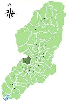
Location of Lozio in Val Camonica
Lozio (Lóh in camunian dialect) is a town and comune in the province of Brescia, in Lombardy. Neighbouring communes are Cerveno, Malegno, Ossimo and Schilpario (BG).
References
This article is issued from Wikipedia - version of the 5/31/2015. The text is available under the Creative Commons Attribution/Share Alike but additional terms may apply for the media files.