Mézery-près-Donneloye
| Mézery-près-Donneloye | ||
|---|---|---|
| Former municipality of Switzerland | ||
| ||
 Mézery-près-Donneloye | ||
|
Location of Mézery-près-Donneloye 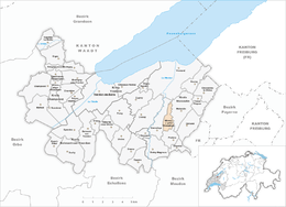 | ||
| Coordinates: 46°45′N 6°44′E / 46.750°N 6.733°ECoordinates: 46°45′N 6°44′E / 46.750°N 6.733°E | ||
| Country | Switzerland | |
| Canton | Vaud | |
| District | Yverdon | |
| Area | ||
| • Total | 1.85 km2 (0.71 sq mi) | |
| Elevation | 625 m (2,051 ft) | |
| Population | ||
| • Total | 75 | |
| • Density | 41/km2 (100/sq mi) | |
| Postal code | 1407 | |
| SFOS number | 5920 | |
| Surrounded by | Donneloye, Molondin, Prahins | |
| Website |
Profile (French), SFSO statistics | |

Mézery-près-Donneloye was a municipality in the district of Yverdon of the canton of Vaud in Switzerland. On January 1, 2008 it merged with Donneloye and Gossens to form Donneloye.[1]
References
- ↑ Amtliches Gemeindeverzeichnis der Schweiz published by the Swiss Federal Statistical Office (German) accessed 19 July 2011
This article is issued from Wikipedia - version of the 12/17/2013. The text is available under the Creative Commons Attribution/Share Alike but additional terms may apply for the media files.