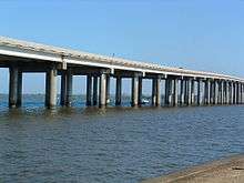
Manchac Swamp Bridge
| Manchac Swamp Bridge | |
|---|---|
 | |
| Coordinates | 30°18′11″N 90°24′21″W / 30.302946°N 90.405807°WCoordinates: 30°18′11″N 90°24′21″W / 30.302946°N 90.405807°W |
| Carries |
|
| Crosses | Manchac Swamp |
| Locale | St. John the Baptist Parish / Tangipahoa Parish, Louisiana, USA |
| Other name(s) | I-55 Manchac Swamp Crossing |
| Maintained by | LA DOTD |
| Characteristics | |
| Total length | 36,710 meters (120,400 feet) |
| Width | 95 m |
| History | |
| Opened | 1979[1] |
The Manchac Swamp Bridge is a twin concrete trestle bridge[1] in the U.S. state of Louisiana. With a total length of 22.80 miles (36.69 km) it is one of the longest bridges in the world over water. Some claim it is the longest toll-free road bridge in the world. The bridge carries Interstate 55 over the Manchac Swamp in Louisiana, and represents one-third of the highway's approximately 66 miles in Louisiana. Opening in 1979,[1] its piles were driven 250 feet (76 m) beneath the swamp and with the cost of the span being $7 million per mile to complete.[2]
See also
References
- 1 2 3 Melaragno, Michele G. (1998). Preliminary Design of Bridges for Architects and Engineers. CRC Press. p. 377. ISBN 978-0-8247-0184-0. Retrieved June 20, 2010.
- ↑ Loh, Jules (June 8, 1977). "Louisiana 'oasis' is cypress-paneled". The Tuscaloosa News. Tuscaloosa, AL. p. 6. Retrieved June 20, 2010.
This article is issued from Wikipedia - version of the 9/21/2016. The text is available under the Creative Commons Attribution/Share Alike but additional terms may apply for the media files.