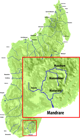
Mandrare River
| Mandrare River | |
| River | |
 | |
| Country | |
|---|---|
| Region | Anosy |
| Tributaries | |
| - left | Manambovo River (above Mahaly), Mananara River (Anosy) (above Amboasary Sud) |
| - right | Andratina River |
| Cities | Mahaly, Amboasary Sud |
| Source | |
| - location | Beampingaratra massif near Trafonaomby peak |
| - elevation | 1,800 m (5,906 ft) |
| Mouth | Indian Ocean |
| - elevation | 0 m (0 ft) |
| - coordinates | MG 25°10′26″S 46°26′00″E / 25.17389°S 46.43333°ECoordinates: MG 25°10′26″S 46°26′00″E / 25.17389°S 46.43333°E |
| Length | 270 km (168 mi) |
| Basin | 12,570 km2 (4,853 sq mi) |
Mandrare is a river in the region of Anosy in southern Madagascar. It flows into the Indian Ocean near Amboasary Sud.
References
This article is issued from Wikipedia - version of the 3/21/2016. The text is available under the Creative Commons Attribution/Share Alike but additional terms may apply for the media files.