Maripasoula Airport
| Maripasoula Airport | |||||||||||
|---|---|---|---|---|---|---|---|---|---|---|---|
| IATA: MPY – ICAO: SOOA | |||||||||||
| Summary | |||||||||||
| Airport type | Public | ||||||||||
| Operator | Conseil Général de la Guyane | ||||||||||
| Serves | Maripasoula, French Guiana | ||||||||||
| Elevation AMSL | 377 ft / 115 m | ||||||||||
| Coordinates | 3°39′27″N 54°02′14″W / 3.65750°N 54.03722°W | ||||||||||
| Map | |||||||||||
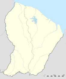 Maripasoula Location of airport in French Guiana | |||||||||||
| Runways | |||||||||||
| |||||||||||
Maripasoula Airport (IATA: MPY, ICAO: SOOA) is an airport located 3.5 km (1.9 NM) north of Maripasoula,[1] a commune in the arrondissement of Saint-Laurent-du-Maroni in French Guiana. It is near the Lawa River, which forms the border between French Guiana and Suriname.
Airlines and destinations
| Airlines | Destinations |
|---|---|
| Air Guyane Express | Cayenne, Grand Santi, Saint-Laurent du Maroni, Saül[5] |
See also
 French Guiana portal
 Aviation portal
- List of airports in French Guiana
- Transport in French Guiana
References
- 1 2 SOOA – Maripasoula. AIP from French Service d'information aéronautique, effective 8 December 2016.
- ↑ Airport information for SO63 from DAFIF (effective October 2006)
- ↑ Airport information for MPY at Great Circle Mapper.
- ↑ Google Maps - Maripasoula
- ↑ "Air Guyane Express". Retrieved 23 August 2010.
External links
This article is issued from Wikipedia - version of the 11/27/2016. The text is available under the Creative Commons Attribution/Share Alike but additional terms may apply for the media files.