Middelie
| Middelie | ||
|---|---|---|
| Village | ||
 | ||
| ||
 | ||
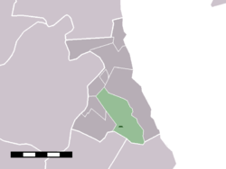 The village centre (dark green) and the statistical district (light green) of Middelie in the former municipality of Zeevang. | ||
| Coordinates: 52°31′56″N 5°1′2″E / 52.53222°N 5.01722°ECoordinates: 52°31′56″N 5°1′2″E / 52.53222°N 5.01722°E | ||
| Country | Netherlands | |
| Province | North Holland | |
| Municipality | Edam-Volendam | |
| Area | ||
| • Total | 8.31 km2 (3.21 sq mi) | |
| Population (2009)[1] | ||
| • Total | 709 | |
| • Density | 85/km2 (220/sq mi) | |
| Time zone | CET (UTC+1) | |
| • Summer (DST) | CEST (UTC+2) | |
| Postal code | 1472 | |
| Dialing code | 0299 | |

Middelie is a village in the Dutch province of North Holland. It is a part of the municipality of Edam-Volendam, and lies about 5 km northeast of Purmerend.
Middelie was a separate municipality until 1970, when the new municipality of Zeevang was created.[2]
In 2001, the small village centre of Middelie had 180 inhabitants. The built-up area of the village centre was 0.03 km², and contained 77 residences.[3] The statistical district "Middelie", which covers the village and the surrounding countryside, has a population of around 690.[4]
References
- ↑ Gemeente Zeevang (2009) "Gemeente in cijfers" Gemeentegids Amsterdam: De Telefoongids BV pp. 7.
- ↑ Ad van der Meer and Onno Boonstra, Repertorium van Nederlandse gemeenten, KNAW, 2006.
- ↑ "Bevolkingskernen in Nederland 2001". Statistics Netherlands (CBS) (in Dutch). Statistics are for the continuous built-up area.
- ↑ "Kerncijfers wijken en buurten 2003-2005". Statistics Netherlands (CBS). As of 1 January 2005
External links
 Media related to Middelie at Wikimedia Commons
- J. Kuyper, Gemeente Atlas van Nederland, 1865-1870, "Middelie". Map of the former municipality, around 1868.
This article is issued from Wikipedia - version of the 3/24/2016. The text is available under the Creative Commons Attribution/Share Alike but additional terms may apply for the media files.