Miracatu
| Miracatu | |
|---|---|
| Municipality | |
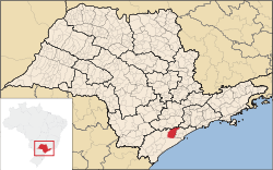 Location in São Paulo state | |
 Miracatu Location in Brazil | |
| Coordinates: 24°16′51″S 47°27′36″W / 24.28083°S 47.46000°WCoordinates: 24°16′51″S 47°27′36″W / 24.28083°S 47.46000°W | |
| Country |
|
| Region | Southeast Region |
| State | São Paulo |
| Area | |
| • Total | 1,001 km2 (386 sq mi) |
| Population (2015) | |
| • Total | 20,533 |
| • Density | 21/km2 (53/sq mi) |
| Time zone | BRT/BRST (UTC-3/-2) |
Miracatu is a municipality in the state of São Paulo in Brazil. The population is 20,533 (2015 est.) in an area of 1001 km².[1] The elevation is 27 m.
The municipality contains a small part of the 84,425 hectares (208,620 acres) Juréia-Itatins Ecological Station, a strictly protected area of well-preserved Atlantic Forest created in 1986.[2]
References
- ↑ Instituto Brasileiro de Geografia e Estatística
- ↑ ESEC Juréia-Itatins (in Portuguese), ISA: Instituto Socioambiental, retrieved 2016-07-19
This article is issued from Wikipedia - version of the 7/19/2016. The text is available under the Creative Commons Attribution/Share Alike but additional terms may apply for the media files.