Mizpah, New Jersey
| Mizpah, New Jersey | |
|---|---|
| Unincorporated community | |
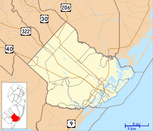 Mizpah  Mizpah  Mizpah Location within Atlantic County. Inset: Location of Atlantic County within New Jersey. | |
| Coordinates: 39°29′12″N 74°50′09″W / 39.48667°N 74.83583°W | |
| Country |
|
| State |
|
| County | Atlantic |
| Township | Hamilton |
| Elevation | 28 m (92 ft) |
| Time zone | Eastern (EST) (UTC-5) |
| • Summer (DST) | EDT (UTC-4) |
| Zip Code | 08342 |
| GNIS feature ID | 878423[1] |
Mizpah is an unincorporated community located within the Mays Landing section of Hamilton Township, in Atlantic County, New Jersey, United States.[2]
Mizpah was established as a Jewish colony in southern New Jersey and was planned out by a New York firm of cloak makers. It originally had a factory, 30 houses, and about 100 settlers.[3]
Uncle Dewey's is a popular barbecue stand located in Mizpah, along U.S. Route 40.[4]
References
- ↑ "Geographic Names Information System (GNIS)". Retrieved July 2, 2011.
- ↑ Locality Search, State of New Jersey. Accessed June 8, 2016.
- ↑ Franklin Dye (1901). New Jersey Hand-book. State Board of Agriculture. p. 27. Retrieved March 23, 2015.
- ↑ Beverly Savage (August 17, 2003). "Where There's Smoke". The New York Times. Retrieved March 23, 2015.
Municipalities and communities of Atlantic County, New Jersey, United States | ||
|---|---|---|
| Cities |  | |
| Boroughs | ||
| Town | ||
| Townships | ||
| CDPs | ||
| Other unincorporated communities | ||
This article is issued from Wikipedia - version of the 6/9/2016. The text is available under the Creative Commons Attribution/Share Alike but additional terms may apply for the media files.