Mount Balbi
| Mount Balbi | |
|---|---|
|
Mount Balbi is the light-colored area at the center of the image. | |
| Highest point | |
| Elevation | 2,715 m (8,907 ft) |
| Prominence | 2,715 m (8,907 ft) |
| Listing | Ultra |
| Coordinates | 5°55′00″S 154°59′00″E / 5.91667°S 154.98333°ECoordinates: 5°55′00″S 154°59′00″E / 5.91667°S 154.98333°E |
| Geography | |
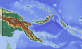 Mount Balbi Papua New Guinea | |
| Location | Bougainville, Papua New Guinea |
| Parent range | Emperor Range |
| Geology | |
| Age of rock | Appr. 10 to 12 000 years ago |
| Mountain type | Stratovolcano |
| Last eruption | Not in historic time |
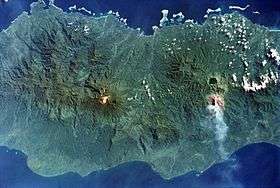
Mount Balbi is a Holocene stratovolcano located in the northern portion of the island of Bougainville, Papua New Guinea. It is the highest point of the island. There are five volcanic craters along a ridge north of the summit, one of which contains a crater lake. There are numerous fumaroles near the craters, though Balbi has not erupted in historic time.
See also
References
This article is issued from Wikipedia - version of the 7/5/2015. The text is available under the Creative Commons Attribution/Share Alike but additional terms may apply for the media files.