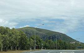
Mount Coolum, Queensland
Not to be confused with Mount Coolum National Park.
| Mount Coolum Sunshine Coast, Queensland | |||||||||||||
|---|---|---|---|---|---|---|---|---|---|---|---|---|---|
 Mount Coolum | |||||||||||||
| Population | 3,669 (2011 census)[1] | ||||||||||||
| Postcode(s) | 4573 | ||||||||||||
| Location | 119 km (74 mi) from Brisbane | ||||||||||||
| LGA(s) | Sunshine Coast | ||||||||||||
| State electorate(s) | Maroochydore | ||||||||||||
| Federal Division(s) | Fairfax | ||||||||||||
| |||||||||||||
Mount Coolum is a suburb in the Sunshine Coast, Queensland, Australia. At the 2011 Australian Census the suburb recorded a population of 3,669.[1] The western boundary of Mount Coolum is aligned with the Sunshine Motorway.
References
- 1 2 Australian Bureau of Statistics (31 October 2012). "Mount Coolum (State Suburb)". 2011 Census QuickStats. Retrieved 29 September 2014.
External links
- Mount Coolum Information from Coolum Website
- University of Queensland: Queensland Places: Mount Coolum
Coordinates: 26°34′S 153°05′E / 26.567°S 153.083°E
This article is issued from Wikipedia - version of the 6/16/2016. The text is available under the Creative Commons Attribution/Share Alike but additional terms may apply for the media files.