Mount Gilbert (Alaska)
| Mount Gilbert | |
|---|---|
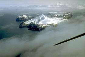 Mount Gilbert from the air, 1994 | |
| Highest point | |
| Elevation | 2,684 ft (818 m) |
| Coordinates | 54°15′08″N 165°39′43″W / 54.2521°N 165.662°WCoordinates: 54°15′08″N 165°39′43″W / 54.2521°N 165.662°W |
| Geography | |
| Location | Akun Island, Alaska, U.S. |
| Parent range | Aleutian Range |
| Geology | |
| Mountain type | Volcano |
| Volcanic arc/belt | Aleutian Arc |
Mount Gilbert is a volcano which forms the northern part of Akun Island in the eastern Aleutian Islands, USA. Active fumaroles were documented 1 mi (1.5 km) northeast of the summit in the early 1900s.
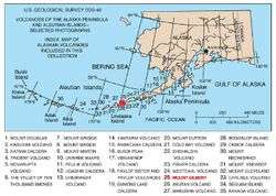
Map of Alaskan volcanoes, with Mount Gilbert marked.
See also
Sources
- Volcanoes of the Alaska Peninsula and Aleutian Islands-Selected Photographs
- Alaska Volcano Observatory
This article is issued from Wikipedia - version of the 1/2/2016. The text is available under the Creative Commons Attribution/Share Alike but additional terms may apply for the media files.