Mount Iizuna
| Mount Iizuna | |
|---|---|
| 飯縄山 | |
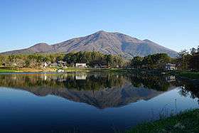 A view from Daizahoushi Pond | |
| Highest point | |
| Elevation | 1,917 m (6,289 ft) |
| Coordinates | 36°44′22″N 138°8′1″E / 36.73944°N 138.13361°ECoordinates: 36°44′22″N 138°8′1″E / 36.73944°N 138.13361°E |
| Naming | |
| Translation | mountain of edible sand (Japanese) |
| Geography | |
 Mount Iizuna Location in Japan | |
| Location | Nagano, Japan |
| Geology | |
| Mountain type | Stratovolcano |
Mount Iizuna (飯縄山 Iizuna-yama), also known as Mount Izuna (飯綱山 Izuna-yama), is a mountain located ten kilometers north-northwest of the heart of Nagano, Nagano Prefecture, Japan. Together with Mount Reisenji (霊仙寺山 Resenji-yama), Mount Menō (瑪瑙山 Menō-yama), and others, it forms the Iizuna range. It has an elevation of 1,917 metres.
This mountain is a sacred site for mountain-based religious sects such as Shugendo, and said to be the home of a tengu named Saburō. According to legend, there was once a strange, edible sand somewhere on the mountain, which the tengu would distribute in times of poor harvest.

The mountain is also a popular area for skiing and is where the bobsleigh and luge track for the 1998 Winter Olympics is located.
External links
- Iizuna Yama - Geological Survey of Japan