Mount Sarbach
| Mount Sarbach | |
|---|---|
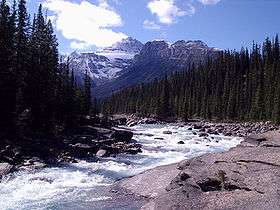 Mount Sarbach seen from Mistaya Canyon | |
| Highest point | |
| Elevation | 3,155 m (10,351 ft) [1] |
| Prominence | 412 m (1,352 ft) [1] |
| Coordinates | 51°52′35″N 116°46′0″W / 51.87639°N 116.76667°WCoordinates: 51°52′35″N 116°46′0″W / 51.87639°N 116.76667°W |
| Geography | |
| Location | Alberta, Canada |
| Parent range | Canadian Rockies |
| Climbing | |
| First ascent | 1897 by J. Norman Collie and G.P. Baker |
Mount Sarbach is a mountain located in Banff National Park between Mistaya River and Howse River and is visible from the Icefields Parkway. The mountain is named after Peter Sarbach, a mountain guide from Switzerland, who guided the first ascend by J. Norman Collie and G.P. Baker in 1897.
References
- 1 2 "Mount Sarbach". Bivouac.com. Retrieved 2009-01-02.
External links
This article is issued from Wikipedia - version of the 3/19/2013. The text is available under the Creative Commons Attribution/Share Alike but additional terms may apply for the media files.