Muel, Ille-et-Vilaine
| Muel Moel | |
|---|---|
|
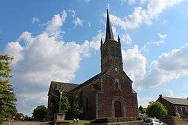
The church of Notre-Dame | |
 Muel | |
|
Location within Brittany region  Muel | |
| Coordinates: 48°07′41″N 2°09′21″W / 48.1281°N 2.1558°WCoordinates: 48°07′41″N 2°09′21″W / 48.1281°N 2.1558°W | |
| Country | France |
| Region | Brittany |
| Department | Ille-et-Vilaine |
| Arrondissement | Rennes |
| Canton | Saint-Méen-le-Grand |
| Intercommunality | Pays de Saint-Méen-le-Grand |
| Government | |
| • Mayor (2014–2020) | Marcel Minier |
| Area1 | 28.90 km2 (11.16 sq mi) |
| Population (2008)2 | 811 |
| • Density | 28/km2 (73/sq mi) |
| Time zone | CET (UTC+1) |
| • Summer (DST) | CEST (UTC+2) |
| INSEE/Postal code | 35201 / 35290 |
| Elevation | 45–133 m (148–436 ft) |
|
1 French Land Register data, which excludes lakes, ponds, glaciers > 1 km² (0.386 sq mi or 247 acres) and river estuaries. 2 Population without double counting: residents of multiple communes (e.g., students and military personnel) only counted once. | |
Muel (Breton: Moel, Gallo: Muèu) is a commune in the Ille-et-Vilaine department in Brittany in northwestern France.
Geography
The river Meu flows from west to east through the commune.
Population
| Historical population | ||
|---|---|---|
| Year | Pop. | ±% |
| 1962 | 773 | — |
| 1968 | 928 | +20.1% |
| 1975 | 803 | −13.5% |
| 1982 | 709 | −11.7% |
| 1990 | 653 | −7.9% |
| 1999 | 648 | −0.8% |
| 2008 | 811 | +25.2% |
See also
References
External links
| Wikimedia Commons has media related to Muel (Ille-et-Vilaine). |
This article is issued from Wikipedia - version of the 11/4/2015. The text is available under the Creative Commons Attribution/Share Alike but additional terms may apply for the media files.