Naebo Station
Naebo Station 苗穂駅 | |
|---|---|
 | |
| Location |
Chūō-ku, Sapporo, Hokkaido Japan |
| Operated by |
|
| Line(s) | |
| Distance | 288.5 km from Hakodate |
| Platforms | 2 island platforms |
| Tracks | 4 |
| Other information | |
| Status | Staffed |
| Station code | H02 |
| History | |
| Opened | May 16, 1910 |
| Traffic | |
| Passengers (FY2014) | 4,176 daily |
Naebo Station (苗穂駅 Naebo-eki) is a railway station in Chūō-ku, Sapporo, Hokkaidō, Japan. It is served by Hakodate Main Line and Chitose Line. The station is numbered H02.[1]
Station layout
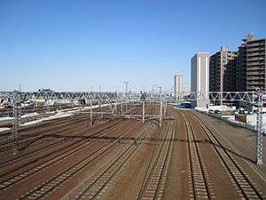
The station consists of two island platforms connected by a footbridge, serving four tracks. The station has automated ticket machines, automated turnstiles which accept Kitaca,[2] and a "Midori no Madoguchi" staffed ticket office.
Platforms
| 3 | ■ Hakodate Main Line | for Sapporo and Otaru |
| 4 | ■ Chitose Line | for Sapporo and Otaru |
| 5 | ■ Chitose Line | for New Chitose Airport and Tomakomai |
| 6 | ■ Hakodate Main Line | for Ebetsu and Iwamizawa |
Adjacent stations
| « | Service | » | ||
|---|---|---|---|---|
| Hakodate Main Line | ||||
| Sapporo (01) | Local | Shiroishi (H03) | ||
| Semi-Rapid: Does not stop at this station[3] | ||||
| Chitose Line | ||||
| Sapporo (01) | Local | Shiroishi (H03) | ||
| Rapid: Does not stop at this station | ||||
Surrounding area
- Toyohira River
-
 National Route 12, (to Asahikawa)
 -
 National Route 275, (to Hamatonbetsu)
 - JR Hokkaido Naebo Workshop, Hokkaido Railway Technology Museum
- JR Hokkaido Naebo Operation Office
- JR Hokkaido Training Center
- JR Freight Vehicle factory
- Sapporo Beer Museum
- Sapporo-Kosei General Hospital
- Sapporo Municipal Central Gymnasium
- Naebo Central Police Station
- Naebo-Ekimae Post Office
- Japan Ground Self-Defense Force Vice-Camp Naebo
- Sapporo City Waterworks Bureau
- ARIO Sapporo, Shopping mall
- Sapporo Factory
- Naebo-Ekimae Kura-no-Yu Onsen
- Satsuraku Agricultural Cooperative Association
- Taiheiyo Cement, Sapporo branch
- Hokkaido Nippon Ham Fighters Indoor Practice Field
References
- ↑ "JR Hokkaido Route Map" (PDF). Hokkaido Railway Company. Retrieved 2016-11-19.
- ↑ "Service Range Kitaca". JR Hokkaido. Retrieved 2016-11-19.
- ↑ "JR HOKKAIDO Railway Lines in Sapporo Area" (PDF). Hokkaido Railway Company. Retrieved 2016-11-19.
External links
Coordinates: 43°4′6.72″N 141°22′38.59″E / 43.0685333°N 141.3773861°E
This article is issued from Wikipedia - version of the 11/21/2016. The text is available under the Creative Commons Attribution/Share Alike but additional terms may apply for the media files.