Nafada
| Nafada | |
|---|---|
| LGA and town | |
 Nafada Location in Nigeria | |
| Coordinates: 11°08′N 11°15′E / 11.133°N 11.250°ECoordinates: 11°08′N 11°15′E / 11.133°N 11.250°E | |
| Country |
|
| State | Gombe State |
| Headquarters | Nafada Town |
| Government | |
| • Local Government Chairman and the Head of the Local Government Council | Umar Adaru El-Nafady |
| • Emir | Muahammudu Dadun Hamza |
| Area | |
| • Total | 1,586 km2 (612 sq mi) |
| Population (2006 census) | |
| • Total | 138,185 |
| Time zone | WAT (UTC+1) |
| 3-digit postal code prefix | 762 |
| ISO 3166 code | NG.GO.NA |
Nafada is a Local Government Area of Gombe State, Nigeria. Its headquarters are in the town of Nafada in the east of the area at11°05′44″N 11°19′58″E / 11.09556°N 11.33278°E, on the Gongola River which traverses the area.
It has an area of 1,586 km² and a population of 138,185 at the 2006 census.
The postal code of the area is 762.[1]
The northeasterly line of equal latitude and longitude passes through the LGA.
References
- ↑ "Post Offices- with map of LGA". NIPOST. Retrieved 2009-10-20.
State capital: Gombe | ||
| LGAs | 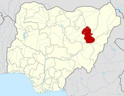 | |
This article is issued from Wikipedia - version of the 8/27/2015. The text is available under the Creative Commons Attribution/Share Alike but additional terms may apply for the media files.