Noordenveld
| Noordenveld | |||
|---|---|---|---|
| Municipality | |||
|
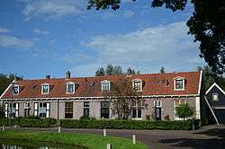
Monumental rowhouses in Veenhuizen | |||
| |||
.svg.png) Location in Drenthe | |||
| Coordinates: 53°8′N 6°26′E / 53.133°N 6.433°ECoordinates: 53°8′N 6°26′E / 53.133°N 6.433°E | |||
| Country | Netherlands | ||
| Province | Drenthe | ||
| Established | 1 January 1998[1] | ||
| Government[2] | |||
| • Body | Municipal council | ||
| • Mayor | Hans van der Laan (PvdA) | ||
| Area[3] | |||
| • Total | 205.32 km2 (79.27 sq mi) | ||
| • Land | 200.99 km2 (77.60 sq mi) | ||
| • Water | 4.33 km2 (1.67 sq mi) | ||
| Elevation[4] | 3 m (10 ft) | ||
| Population (May 2014)[5] | |||
| • Total | 31,138 | ||
| • Density | 155/km2 (400/sq mi) | ||
| Time zone | CET (UTC+1) | ||
| • Summer (DST) | CEST (UTC+2) | ||
| Postcode | 9300–9349, 9749 | ||
| Area code | 050, 0516, 0592, 0594 | ||
| Website |
gemeentenoordenveld | ||
Noordenveld [ˈnʊːrdə(ɱ)vɛɫt] (![]() pronunciation ) is a municipality in the northeastern Netherlands.
pronunciation ) is a municipality in the northeastern Netherlands.
Population centres
Altena, Alteveer, Amerika, Boerelaan, De Horst, De Pol, Een, Een-West, Foxwolde, Huis ter Heide, Langelo, Leutingewolde, Lieveren, Matsloot, Nietap, Nieuw-Roden, Norg, Norgervaart, Peest, Peize, Peizermade, Peizerwold, Roden, Roderesch, Roderwolde, Sandebuur, Steenbergen, Terheijl, Veenhuizen, Westervelde and Zuidvelde.
Topography
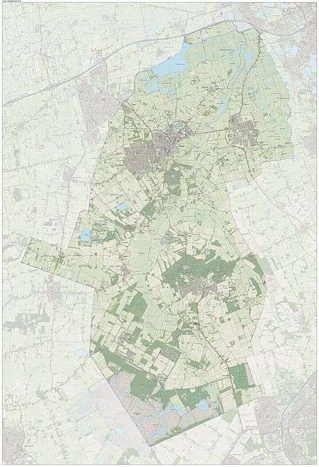
Dutch Topographic map of the municipality of Noordenveld, June 2015.
Water Board Noordenveld
Noordenveld is also the name of a former Water Board, which had its office in Roden. Water Board Noordenveld arose from the Water Boards of Leutingewolde (1866-1967), De Zuidermaden (1914-1967), De Weehorst (1917-1967), De Peizer en Eeldermaden (1928-1984) and Matsloot-Roderwolde (1933-1984).[6]
In 1995, Water Board Noordenveld was merged into Water Board Noorderzijlvest, based in Onderdendam.[7]
References
- ↑ "Gemeentelijke indeling op 1 januari 1998" [Municipal divisions on 1 January 1998]. cbs.nl (in Dutch). CBS. Retrieved 5 October 2013.
- ↑ "Hans van der Laan" (in Dutch). Gemeente Noordenveld. Retrieved 11 October 2013.
- ↑ "Kerncijfers wijken en buurten" [Key figures for neighbourhoods]. CBS Statline (in Dutch). CBS. 2 July 2013. Retrieved 12 March 2014.
- ↑ "Postcodetool for 9301AA". Actueel Hoogtebestand Nederland (in Dutch). Het Waterschapshuis. Retrieved 11 October 2013.
- ↑ "Bevolkingsontwikkeling; regio per maand" [Population growth; regions per month]. CBS Statline (in Dutch). CBS. 26 June 2014. Retrieved 24 July 2014.
- ↑ "Noorderzijlveld: Rechtsvoorgangers. Waterschap Noorderzijlveld" (in Dutch). Retrieved 10 June 2015.
- ↑ nl:Noordenveld (waterschap)
External links
| Wikivoyage has a travel guide for Noordenveld. |
 |
Leek (GR) | Groningen (GR) | | |
| Opsterland (FR) | |
Tynaarlo | ||
| ||||
| | ||||
| Ooststellingwerf (FR) | Midden-Drenthe | Assen |
Municipalities of Drenthe | ||
|---|---|---|
 | ||
| ||