Ohio State Route 147
| ||||
|---|---|---|---|---|
 | ||||
| Route information | ||||
| Maintained by ODOT | ||||
| Length: | 58.40 mi[1] (93.99 km) | |||
| Existed: | 1923 – present | |||
| Major junctions | ||||
| West end: |
| |||
| East end: |
| |||
| Location | ||||
| Counties: | Noble, Belmont | |||
| Highway system | ||||
| ||||

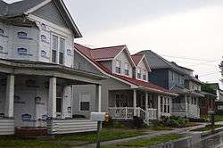
Houses in Bethesda
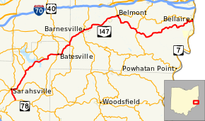
State Route 147 (SR 147) is an east-west state highway in the eastern portion of the U.S. state of Ohio. Its eastern terminus is at State Route 7 near Bellaire, with its western terminus at SR 78 in Noble County, Ohio. The highway passes near Senecaville Lake near Batesville.[2]
History
SR 147 was commissioned in 1923, along its current route.[3][4] In 1930, the western terminus was moved to an intersection to the newly commissioned SR 146, in Sarahsville.[5][6] The western terminus was moved back to its current location in 1932.[7][8]
Major intersections
| County | Location | mi[1] | km | Destinations | Notes |
|---|---|---|---|---|---|
| Noble | Center Township | 0.00 | 0.00 | ||
| Sarahsville | 2.60 | 4.18 | Western end of SR 146 concurrency | ||
| Center Township | 3.50 | 5.63 | Eastern end of SR 146 concurrency | ||
| Seneca Township | 8.06 | 12.97 | Southern terminus of SR 566 | ||
| Beaver Township | 13.56 | 21.82 | Eastern terminus of SR 313 | ||
| Batesville | 17.03 | 27.41 | Western end of SR 513 concurrency | ||
| 17.11 | 27.54 | Eastern end of SR 513 concurrency | |||
| Belmont | Somerset Township | 21.06 | 33.89 | Northern terminus of SR 379 | |
| Warren Township | 22.18 | 35.70 | Eastern terminus of SR 265 | ||
| Barnesville | 25.54 | 41.10 | Western end of SR 800 concurrency | ||
| 25.98 | 41.81 | Eastern end of SR 800 concurrency | |||
| Goshen Township | 34.19 | 55.02 | Western end of SR 149 concurrency | ||
| Belmont | 34.70 | 55.84 | Western end of SR 149 concurrency | ||
| Smith Township | 40.64 | 65.40 | Western end of SR 9 concurrency | ||
| 41.41 | 66.64 | Eastern end of SR 9 concurrency | |||
| Pultney Township | 58.23– 58.40 | 93.71– 93.99 | Interchange | ||
1.000 mi = 1.609 km; 1.000 km = 0.621 mi
| |||||
References
- 1 2 Ohio Department of Transportation. "Technical Services Straight Line Diagrams". Retrieved October 13, 2013.
- ↑ Google (October 13, 2013). "Ohio State Route 147" (Map). Google Maps. Google. Retrieved October 13, 2013.
- ↑ Ohio Department of Highways and Public Works (April 1922). Map of Ohio State Highways (MrSID) (Map). Columbus: Ohio Department of Highways and Public Works. Retrieved October 22, 2013.
- ↑ Ohio Department of Highways and Public Works (July 1923). Map of Ohio Showing State Routes (MrSID) (Map). 1:760,320. Columbus: Ohio Department of Highways and Public Works. Retrieved October 22, 2013.
- ↑ Ohio Department of Highways (August 15, 1929). Map of Ohio Showing State Routes (MrSID) (Map). 1:760,320. Columbus: Ohio Department of Highways. OCLC 5673562, 7438560. Retrieved October 22, 2013.
- ↑ Ohio Department of Highways (1930). Map of Ohio Showing State Routes (MrSID) (Map). 1:760,320. Columbus: Ohio Department of Highways. OCLC 5673562, 7237073. Retrieved October 22, 2013.
- ↑ Ohio Department of Highways (1931). Map of Ohio Showing State Routes (MrSID) (Map). 1:760,320. Columbus: Ohio Department of Highways. OCLC 5673562, 7231737. Retrieved October 22, 2013.
- ↑ Ohio Department of Highways (1932). Map of Ohio Showing State Routes (MrSID) (Map). 1:760,320. Columbus: Ohio Department of Highways. OCLC 5673562, 7231704. Retrieved October 22, 2013.
This article is issued from Wikipedia - version of the 7/10/2015. The text is available under the Creative Commons Attribution/Share Alike but additional terms may apply for the media files.