Otoyol 30
| |
|---|---|
| Otoyol 30 | |
|
Izmir Beltway İzmir Çevreyolu | |
 | |
| Route information | |
|
Part of | |
| Major junctions | |
| From: | Şehitlik, Izmir |
| To: | Balatçık, Izmir |
| Location | |
| Regions: | Aegean |
| Provinces: | Izmir Province |
| Major cities: | Izmir |
| Highway system | |

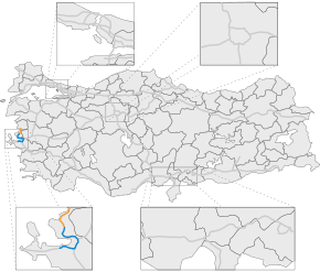
Otoyol 30 (English: Motorway 30), abbreviated as O-30, aka İzmir Çevreyolu (English: Izmir Beltway), is a motorway in Izmir, Turkey that forms the beltway of the city running from south to north around the Gulf of Izmir.
It starts in Şehitlik neighborhood, where the İzmir-Çeşme Otoyolu (English: Izmir-Çeşme Motorway) ends and terminates in Çiğli neighborhood. Otoyol 30 is toll-free. It is linked to the İzmir-Aydın Otoyolu (English: Izmir-Aydın Motorway) in Işıkkent junction. The beltway is part of the European routes ![]() between Şehitlik-Işıkkent, and
between Şehitlik-Işıkkent, and ![]() between Işıkkent-Atatürk OSB.
between Işıkkent-Atatürk OSB.
| | ||
|---|---|---|
| |
İkiztepe (Marina) | |
| |
Limontepe | |
| |
Uzundere | |
| |
Gaziemir | |
| |
Buca | Doğuş Street |
| |
DEÜ Campus - KGM Factory Area | |
| |
Kaynaklar | |
| |
Pınarbaşı | |
| |
Otogar | |
| |
Sanayi-Karacaoğlan | |
| |
Bornova Viaduct | |
| |
Ege University | |
| |
Atatürk Mahallesi | |
| |
Bornova | |
| |
Cengizhan | |
| |
Bayraklı-2 Tunnel 1,865 and 1,876 m (6,119 and 6,155 ft)[1] |
|
| |
Doğançay Viaduct | |
| |
Bayraklı-1 Tunnel 320 and 317 m (1,050 and 1,040 ft)[1] |
|
| |
Onur Mahallesi | |
| |
Karşıyaka | |
| |
Karşıyaka-Batı | |
| |
Çiğli | |
| |
Mavişehir | |
| |
Atatürk OSB (Atatürk Industrial Zone) |
|
| |
Sasalı | |
| |
Havaüssü | |
| |
Seyrek | |
| |
Koyundere | |
See also
References
| Marmara Region |
| |
|---|---|---|
| Black Sea Region | ||
| Central Anatolia Region | ||
| Aegean Region | ||
| Mediterranean Region | ||
| Southeastern Anatolia Region | ||
| Former numbers | ||
| Under construction | ||
| Planned |
| |
This article is issued from Wikipedia - version of the 7/27/2016. The text is available under the Creative Commons Attribution/Share Alike but additional terms may apply for the media files.