Podvolovljek
| Podvolovljek | |
|---|---|
 | |
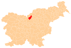
 Podvolovljek Location in Slovenia | |
| Coordinates: 46°18′21.15″N 14°41′49.64″E / 46.3058750°N 14.6971222°ECoordinates: 46°18′21.15″N 14°41′49.64″E / 46.3058750°N 14.6971222°E | |
| Country |
|
| Traditional region | Styria |
| Statistical region | Savinja |
| Municipality | Luče |
| Area | |
| • Total | 18.9 km2 (7.3 sq mi) |
| Elevation | 646.7 m (2,121.7 ft) |
| Population (2002) | |
| • Total | 202 |
| [1] | |
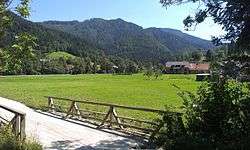
Podvolovljek (pronounced [pɔdʋɔˈloːu̯jɛk]) is a settlement in the Municipality of Luče in Slovenia. Traditionally the area belonged to the region of Styria and is now included in the Savinja Statistical Region.[2]
The local church is dedicated to Saint Anthony the Hermit and belongs to the Parish of Luče. It was first mentioned in written documents dating to 1631.[3]
References
External links
| Settlements | Administrative centre: Luče
|  |
|---|---|---|
| Landmarks |
| |
This article is issued from Wikipedia - version of the 7/30/2016. The text is available under the Creative Commons Attribution/Share Alike but additional terms may apply for the media files.