Pudagla
| Pudagla | ||
|---|---|---|
| ||
 Pudagla | ||
Location of Pudagla within Vorpommern-Greifswald district 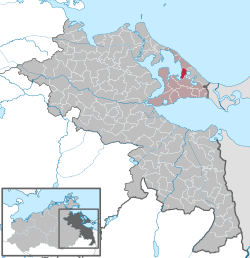 | ||
| Coordinates: 53°58′N 14°04′E / 53.967°N 14.067°ECoordinates: 53°58′N 14°04′E / 53.967°N 14.067°E | ||
| Country | Germany | |
| State | Mecklenburg-Vorpommern | |
| District | Vorpommern-Greifswald | |
| Municipal assoc. | Usedom-Süd | |
| Government | ||
| • Mayor | Fred Fischer | |
| Area | ||
| • Total | 13.26 km2 (5.12 sq mi) | |
| Population (2015-12-31)[1] | ||
| • Total | 454 | |
| • Density | 34/km2 (89/sq mi) | |
| Time zone | CET/CEST (UTC+1/+2) | |
| Postal codes | 17429 | |
| Dialling codes | 038378 | |
| Vehicle registration | VG | |

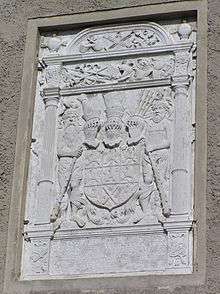
Coat of Arms of the House of Pomerania, Pudagla palace
Pudagla is a municipality in the Vorpommern-Greifswald district, in Mecklenburg-Vorpommern, Germany. From 1307/09 until the Protestant Reformation, it was the site of Pudagla or Usedom Abbey, which moved there from Usedom (town) (Grobe Abbey). After the abbey's secularization into a ducal domain, it at times served as an administrative center. Historical buildings are the former monastery church, some further ruins of the abbey, and a palace.
References
This article is issued from Wikipedia - version of the 11/6/2016. The text is available under the Creative Commons Attribution/Share Alike but additional terms may apply for the media files.