Quebec Route 162
| ||||
|---|---|---|---|---|
 | ||||
| Route information | ||||
| Maintained by Transports Québec | ||||
| Length: | 23.9 km[1] (14.9 mi) | |||
| Major junctions | ||||
| South end: |
| |||
|
| ||||
| North end: |
| |||
| Location | ||||
| Counties: | Arthabaska | |||
| Major cities: | Victoriaville | |||
| Highway system | ||||
| ||||

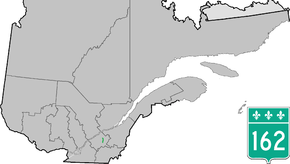
Route 162 is a short 24 km highway on the south shore of the St. Lawrence River in Quebec, Canada, linking Autoroute 20 in Saint-Louis-de-Blandford and Victoriaville, at the junction of Route 122.
Municipalities along Route 162
See also
References
- ↑ Ministère des transports, "Distances routières", page 73, Les Publications du Québec, 2005
External links
This article is issued from Wikipedia - version of the 11/7/2014. The text is available under the Creative Commons Attribution/Share Alike but additional terms may apply for the media files.