Ramganj Upazila
| Ramganj রামগঞ্জ | |
|---|---|
| Upazila | |
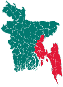
 Ramganj Location in Bangladesh | |
| Coordinates: 23°6.3′N 90°52.5′E / 23.1050°N 90.8750°ECoordinates: 23°6.3′N 90°52.5′E / 23.1050°N 90.8750°E | |
| Country |
|
| Division | Chittagong Division |
| District | Lakshmipur District |
| Area | |
| • Total | 169.31 km2 (65.37 sq mi) |
| Population (2011) | |
| • Total | 342,027 |
| • Density | 2,000/km2 (5,200/sq mi) |
| Time zone | BST (UTC+6) |
| Website | http://ramganj.lakshmipur.gov.bd |
Ramganj (Bengali: রামগঞ্জ) is an Upazila of Lakshmipur District in the Division of Chittagong, Bangladesh.[1]
The Ramganj Upazila area is located at 2301 and 2311 and 90.48 north latitude and 90.58 east longitude. It was established in 1891 and 4/07/1983 AD. Sadar Upazila is located on the north Faridganj, Hajiganj thesaharasti and Chatkhil west and Raipur Faridganj south.
Geography
Ramganj is located at 23°06′20″N 90°52′30″E / 23.1056°N 90.8750°E.
Statistics
|
Distance from district headquarters |
12 km |
|
Volume |
169.31 |
|
Population |
342027 |
|
The density of the number of people |
২0২0 (per square kilo meters) |
|
Total voters (UP selection / per 011) |
171292 people |
|
Men |
80267 John |
|
Women |
91025 John |
|
The annual population growth rate |
1.92% |
|
Constituency |
274 National Assembly seats (-1 Lakshmipur ramganj) |
|
Village |
126 T |
|
Village |
140 |
|
Union |
10 |
|
Municipality |
1, 9 wards, 18 mahallas |
|
Mosque |
242 T |
|
Mausoleum |
4 |
|
Shrine |
1 |
|
Temple |
1 T |
|
Monastery |
1 |
|
Harishobha |
8 |
|
Rivers |
There is no |
|
Hats |
4 |
|
Bank branch |
14 |
|
Post Office / Sub Post Office |
35 |
|
Renamed |
'Ram', named after an influential local leader |
|
Foothold |
ENG 1891 |
|
Unnitakarana police station |
AD 24031983 |
Demographics
According to the 2011 Bangladesh census, Ramganj had a population of 342027. Males constituted 47.98% of the population, and females 52.02%. Of the total population, only 171270 people are over the age of 18, meaning that more than 52.6% of the population is younger than 18. Ramganj has an average literacy rate of 45%, 12.6 percentage points above the national average of 32.4%.[2]
Administration
Ramganj has 10 Unions, 1 municipality, 152 Mauzas/Mahallas, and 126 villages.
References
- ↑ Mohammad Nur Hossain (2012). "Ramganj Upazila". In Sirajul Islam and Ahmed A. Jamal. Banglapedia: National Encyclopedia of Bangladesh (Second ed.). Asiatic Society of Bangladesh.
- ↑ "Population Census Wing, BBS.". Archived from the original on 2005-03-27. Retrieved November 10, 2006.
| Upazila/Thana: | ||
|---|---|---|