Raschau-Markersbach
| Raschau-Markersbach | |
|---|---|
 Raschau-Markersbach | |
Location of Raschau-Markersbach within Erzgebirgskreis district 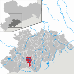 | |
| Coordinates: 50°31′56″N 12°52′17″E / 50.53222°N 12.87139°ECoordinates: 50°31′56″N 12°52′17″E / 50.53222°N 12.87139°E | |
| Country | Germany |
| State | Saxony |
| District | Erzgebirgskreis |
| Area | |
| • Total | 39.52 km2 (15.26 sq mi) |
| Population (2015-12-31)[1] | |
| • Total | 5,209 |
| • Density | 130/km2 (340/sq mi) |
| Time zone | CET/CEST (UTC+1/+2) |
| Postal codes | 08352 |
| Dialling codes | 03774 |
| Vehicle registration | ERZ |
| Website | www.markersbach.de |
Raschau-Markersbach is a municipality in the district of Erzgebirgskreis in Saxony, Germany. It was formed on 1 January 2008, by the merger of the former municipalities Markersbach and Raschau.
Gallery
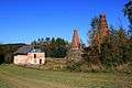 Ruins of the lime plant
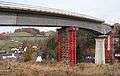 Looking through the bridge under construction of the bypass stream marker (B101) on the marker Bacher Viaduct
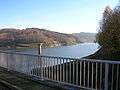 Pumped storage plant markers (Bach Dam)
 Elementary school
References
| Wikimedia Commons has media related to Raschau-Markersbach. |
This article is issued from Wikipedia - version of the 7/21/2015. The text is available under the Creative Commons Attribution/Share Alike but additional terms may apply for the media files.