Rifle River
| Rifle River | |
| River | |
| Country | United States |
|---|---|
| State | Michigan |
| Counties | Ogemaw, Arenac |
| Cities | Selkirk, Omer |
| Source | |
| - location | Ogemaw County, Michigan, United States |
| - coordinates | 44°23′58″N 84°01′57″W / 44.39944°N 84.03250°W |
| Mouth | Saginaw Bay |
| - location | Arenac County, Michigan, United States |
| - elevation | 577 ft (176 m) |
| - coordinates | 43°59′34″N 83°49′15″W / 43.99278°N 83.82083°WCoordinates: 43°59′34″N 83°49′15″W / 43.99278°N 83.82083°W |
| Length | 60 mi (97 km) |
| Basin | 385 sq mi (997 km2) |
| Discharge | for Saginaw Bay |
| - average | 181 cu ft/s (5 m3/s) |
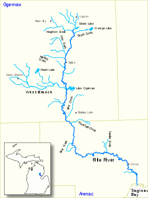 | |
Rifle River is a 60.3-mile-long (97.0 km)[1] river in the U.S. state of Michigan. It rises in northeastern Ogemaw County and flows through Arenac County to enter Saginaw Bay of Lake Huron.[2] Once a logging river during the Michigan forestry boom at the turn of the 20th century, the river is now primarily used for recreation, and is a state-designated natural river. It is a popular river for canoeing, with no portages or dams and an average depth of 18 inches, to 5 feet in downtown Omer. It is also known for having one of the best White Sucker (Catostomus commersonii) runs in the state of Michigan, in the spring.
.jpg)
According to a historical map of Michigan originally published in 1831, the Rifle River may have previously been referred to as Grindstone Creek.[3]
Canoe liveries serving the Rifle River
Several private canoe operators provide equipment rental and transportation for river trips along the Rifle River.
[Twining, Mi] Whispering Pines Campground and Canoe Livery. http://www.michigan.org/property/whispering-pines-campground-and-canoe-livery/
Sterling, MI (Central portion of the Rifle River - Most Popular)
- River View Campground & Canoe Livery
- Whites Campground & Canoe Livery
- Rifle River Campground & Canoe Livery
Omer, MI (Lower portion of the Rifle River)
See also
References
- ↑ U.S. Geological Survey. National Hydrography Dataset high-resolution flowline data. The National Map Archived 2012-04-05 at WebCite, accessed November 7, 2011
- ↑ "Rifle River". Geographic Names Information System. United States Geological Survey.
- ↑ Michigan State University Map Library
External links
| Wikimedia Commons has media related to Rifle River. |