Rimondeix
| Rimondeix | |
|---|---|
 Rimondeix | |
|
Location within Nouvelle-Aquitaine region  Rimondeix | |
| Coordinates: 46°13′47″N 2°06′10″E / 46.2297°N 2.1028°ECoordinates: 46°13′47″N 2°06′10″E / 46.2297°N 2.1028°E | |
| Country | France |
| Region | Nouvelle-Aquitaine |
| Department | Creuse |
| Arrondissement | Guéret |
| Canton | Jarnages |
| Intercommunality | Carrefour des Quatre Provinces |
| Government | |
| • Mayor (2008–2014) | Serge Jannot |
| Area1 | 8.03 km2 (3.10 sq mi) |
| Population (2008)2 | 98 |
| • Density | 12/km2 (32/sq mi) |
| Time zone | CET (UTC+1) |
| • Summer (DST) | CEST (UTC+2) |
| INSEE/Postal code | 23161 / 23140 |
| Elevation |
353–444 m (1,158–1,457 ft) (avg. 452 m or 1,483 ft) |
|
1 French Land Register data, which excludes lakes, ponds, glaciers > 1 km² (0.386 sq mi or 247 acres) and river estuaries. 2 Population without double counting: residents of multiple communes (e.g., students and military personnel) only counted once. | |
Rimondeix is a former commune in the Creuse department in the Limousin region in central France. On 1 January 2016, it was merged into the new commune Parsac-Rimondeix.[1]
Geography
A small farming area, comprising the village and two hamlets situated some 11 miles (18 km) northeast of Guéret, at the junction of the D9 and the D66 roads.
Population
| Historical population | ||
|---|---|---|
| Year | Pop. | ±% |
| 1962 | 140 | — |
| 1968 | 118 | −15.7% |
| 1975 | 106 | −10.2% |
| 1982 | 71 | −33.0% |
| 1990 | 78 | +9.9% |
| 1999 | 73 | −6.4% |
| 2008 | 98 | +34.2% |
Sights
- The church, dating from the twelfth century.
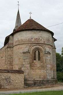
Rimondeix church
See also
References
- ↑ Arrêté préfectoral 23 September 2015 (French)
External links
| Wikimedia Commons has media related to Rimondeix. |
- Rimondeix on the Quid website (French)
This article is issued from Wikipedia - version of the 8/16/2016. The text is available under the Creative Commons Attribution/Share Alike but additional terms may apply for the media files.